This route is definitely not for the faint hearted but worth every step and hour spent canvassing these mountains from the bottom of Llandudno, over the 12 Apostle Mountains, through the submontane of Table Mountain, to the famous top. I’m sure you will find this journey very eesome.
(Eesome: Pleasing to the eye)
(Submontane: Passing through or under mountains)
Information
Destination: Cape Town
Distance: ±15km
Duration: 7h (If you don’t get lost)
Level: Some dangerous areas
Route: The map was constructed on Google Earth from 3 different origins to complete. If you want more information on it please contact me here.

Start of the correct route on the map was used from
http://hike-cape-town.blogspot.co.za/2011/07/hike-hout-bay-corner.html
Best hiking maps for South Africa you can buy at
https://slingsby-maps.myshopify.com/products/table-mountain
Start coordinates: 34°00’38.6″S 18°21’03.4″E
End coordinates: 33°57’29.2″S 18°24’12.2″E
Notes:
Sunscreen!!!!
Water
Snacks
Camera
Starting off the journey


Hiking Table Mountain was on our list of to-do things, for our week holiday trip in Cape Town. Deciding to avoid one of the most popular routes, the Platteklip Gorge, we opted for a longer uncommon track over the mountains. With that decision, we traded a steep, zig-zag, 2 hours ascend for an 8 hour, picturesque monadh. Not being sure exactly where to start and relying on information from a local, maps and research (the almost non-existent extensive information available on this specific route), we set off early in the morning to avoid getting caught too much in the scorching African sun – we were too late. Despite the maps information of where the different routes start, we had some trouble finding it. Some of the routes have been created in the 1800’s and are dangerous and inactive but still display on the maps. After wandering in and out of the war batteries and being advised by the supervisor to walk up the mountain just outside the gate, we finally started our journey.
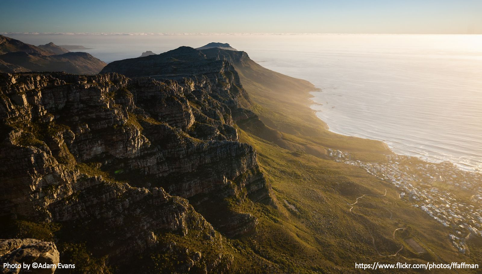
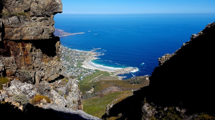
There was no indication of a path of some sort but the only way was up. On the map, there was a proper route at the top we would get to. After a bit of bundu-bashing (African thing: ‘bundu’ means wild, bushes), clambering over boulders and quickly sprinting over grassy bushes to avoid possible snakes, we reached the top. Finally a path too! Close to reaching our first summit, there were 2 people at the top inspecting our climb. The one seemed to be a trail tour guide for the other. He looked at us with surprise and said, “I have never heard of or seen anyone come up this way before. I thought you would have more scratches on your legs!” .Sweat dripping down our faces and trying to catch our breath, we just laughed and had a quick affirmation that the road onwards is fairly easy and visible (Not in our case). At the top of the Peak, we could overlook Llandudno and Hout Bay, both joining the ocean. A marvellous site, that leaves you staring in silence at the beauty. After having a water break, a snack and taking some pictures, we had to continue with the journey, which was still a long way ahead.
(Monadh: (Scottish) A moorland covered mountain)
Venturing the 12 Apostles Mountain range
The second part of the trail started fairly easy, following the footpath over and around the hills but with no signposts where the path would split. We did encounter cairns along the way. After the first km, we were wandering on a path on the side of the cliff, a steep angled descend on the left with the road and ocean far below, and the cliff face rising up on your right. A marvellous sight. It was here where the trail becomes less obvious and we followed the route that seemed like the right one, it was not! Crossing over the small rocky ravine, we carefully surveyed the spot, trying to find an indication of where to go, footprints from our surprised hikers from the morning or a path leading somewhere. Finally, after what seemed too long, we traced our steps back and started making our way upwards, before the ravine. We happened upon a few metal rungs to pull yourself up onto the rocks. This meant we were either on an old path if not the right one, it didn’t matter since they all would lead to the next mountain top where we had to be.

At the top, we were once again the montivagant hikers, on a footpath, with no signposts but Cairns to confirm our route. The landscape of the mountains changes from flat open spaces at the top of the mountain, to wandering through waist high bushes and grassland lands that lead down to shaded alcoves. Where the boulders tower over to provide the shelter, you can hear a rippling stream somewhere close and the green undergrowth adds more colour to the already captivating landscape. The rocks are cold to touch and the shade is welcomed with immense appreciation. We encountered a few of these spots along the way, which provides wonderful refreshing opportunities.
(Montivagant: Wandering over hills and mountains)
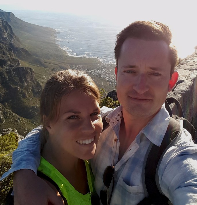
 In the beaming sunlight, enough water was a necessity, which we ran out of 2 hours before we would arrive at our destination. This was due to misjudging a number of mountains to cross when we thought it was the last ascend to get to the top…There were 2 more, and it’s not hills, it’s mountains. Getting closer to the more travelled paths, we came across signposts! Even though they were there, most of them weren’t that specific that you can link it to where you are on the map (That added to us misjudging our position compared to the end) but the view made it all worth it. As the last incline stared us in the face (known as the ladders on the map), new motivation evolved. We crossed wooden pathways, scrambled up rocks and boulders and climbed up metal ladders to finally reach the famous Table Mountain Top.
The sunset descend
At the top, we had a shorter walk to get to the restaurant that held lifesaving refreshments. You will definitely know you’ve arrived as thousands of people walk about, sitting at the edges for photos and the views, others relieved to have reached the top from different routes. Each of us had at least 3 refreshments in a matter of minutes to replenish our bodies. We wandered through the gift shops and found a space to take photos.
As it turned out we arrived at the perfect time, the sun was setting slowly. Looking to the one side we could see the mountain ranges we have just crossed, amazing! We did that! It seemed difficult to grasp the idea we made it so far… We had the ocean stretching out to Robben Island in the middle in another view, Lions Head and Signal Hill to the other and Cape Town’s city life on the other side. So many incredible sights to choose from. There were hyrax, or “dassies” as we call them in Afrikaans, running around in between people.
Everyone was taking a spot to watch the sunset from the top, we managed to get on one of the first cable cars going down as the alarm sounded, to let people know it’s time to leave. In mid-air, with a rotating view, we got to see the sunset over the Atlantic Ocean, with colours so vibrant, it warmed the sky and lit up faces with smiles.
The adventure’s end
It was a long successful day. A wondrous route, that tests you but worth every second of it…and we will definitely do it again. It’s a journey photophiles will love and hikers will remember for years to come. You build memories and it imprints views that leave you breathless. You’ll understand why it’s one of the 7 wonders of the world.
(Photophile: A person who loves photography and light)
Would you like more information about this route?
Please leave a comment below or share your story.
To join me on more adventures, sign-up here.

tablets tablets
LikeLike
lovely! Self-Charging Smartphones Enter Market 2025 cool
LikeLike